 Thanks for all the suggestions and ideas about how to naturally navigate from trees in spring time - here's how I started thinking about the problem.
The navigational information here is coming from trees, and how the first shoots of spring come at different times depending upon geometry, most particularly how they are orientated with respect to the sun.
The photo above is the starting point, though it was actually taken afterwards.
What can be seen is that each tree starts showing signs of life across the whole tree at once: there maybe a slight difference on opposite sides, but that is a secondary effect, and looking at many of the trees either here or in the park couldn't see a huge difference in terms of number and sizes of leaf on north vs south branches.
That's probably related to how trees work: I'm no expert but guess the bio-chemical messages that say "spring is here" are transmitted around the whole tree at once, though will be triggered at different times depending upon the tree's location.
Though there is some navigational information in this first picture it could be dangerous to make an assessment from just this source. Firstly the tree to the right might just be a bit more to the south of the one to the right, not due south. Then it is a built up area and there could be other factors such as building shadow, drainage etc and so while it is an indicator, there is potential for error.
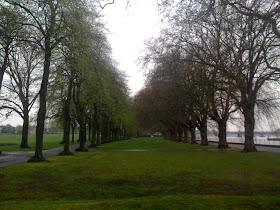
However for the picture of the avenue it's not just one tree but a whole load of them, and in particular:
1) All trees show the same effect: all the ones to the left are much further out than any of the ones to the right. So statistically this is a very strong signal
2) The difference between the trees to the left and right is pretty much the same all the way down.
 If this avenue were aligned south-east or south-west you might see the ones at one end being different from the other end. But in this case they weren't: the trees were very similar all the way along.
Hence I'd suggest this shows the avenue is close to east-west, and the south is on the left hand side so we are looking close to west.
So about a trillian points to the Natural Navigator himself (who spotted a lot more than I did in the photo), points to Tillerman and Carol Anne for thinking on the right lines, while O'Docker of course gets the special "Google" prize for correctly finding the direction and location.
This actually is the avenue in Wandsworth Park which you can spot on Google Maps by clicking here: I was slightly surprised to see the avenue actually points slightly off east-west by 10 - 20 degrees. That's an easy mistake to make with the Thames on one side as it wiggles a lot so actually doesn't flow west to east that often.
I hope you all found this interesting: for me thats one of the key benefits of thinking about navigating naturally: you look at the world around you in new eyes and spot details and are aware of it much more.
Also, look at the base of the trees and the branches.
ReplyDeleteMore branches on the south side
Small plants around the base are growing more on the south side with more sunlight.
Sounds like you should go on one of Tristan's Natural Navigation course - full of observations like that but puts them in an overall context.
ReplyDelete