Tuesday, September 12, 2017

The Great River Race 2017


This weekend was super busy with Classic Boats at St. Katharine Dock, the amazing installation Future Dust and the closing of the Thames Barrier, all to come.

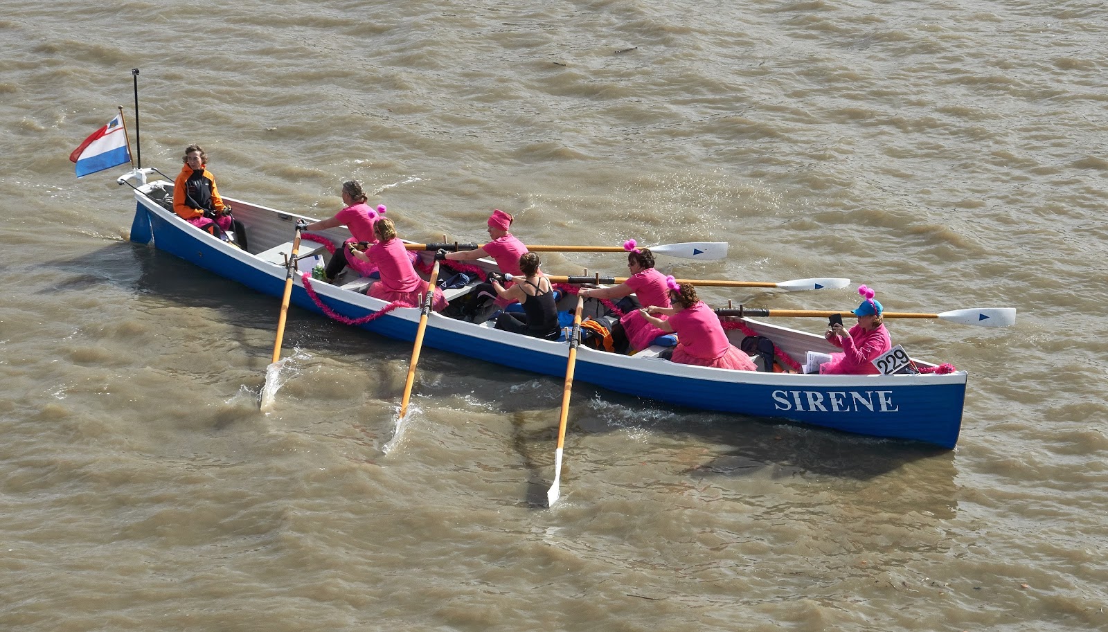
There was also a friend's baby's first birthday to fit in and it was on the way to that when looked out over the Thames to see the rowers heading upstream for the Great River Race:


But I was already late and had promised to bring with me a cake so only had time for a few snaps before heading off:


Sunday, September 10, 2017

The Ferries of London: the secret Greenwich Ferry

I thought I'd completed my summer project of visiting all the London Ferries and all the London Stones when someone tipped me off about the secret Greenwich ferry.

This one connects North Greenwich, home of the O2 dome (above) with Trinity Buoy Wharf, which I've previously blogged about as being wonderfully full of character.

Luckily soon after this discovery I had a meeting near London Bridge that finished in the early afternoon so I headed on the Jubilee Line to North Greenwich to check it out.

And there it was, as rumoured. It goes from a pier used by Thames Clipper but its not identified on their route map:
It's run by Predator Charters Maritime Services and there's no mention of it on their web site, just a cryptic comment about vessel "Predator II under contract to Thames Clippers as crew transfer vessel".

And that's apparently why its running as a ferry but not publicised: for this vessel's primary purpose is to provide Thames Clipper staff with transport. On the north side of the Thames, at Trinity Wharf, there are offices (including the head office, Clipper House) support facilities and Thames Clipper boats are moored while the south side, called North Greenwhich, is where they dock to zip up and down river. So the staff need to be able to go between the two.

But members of the public can use it too if there is room. There is some information about this service if you hunt around, such as on the Trinity Buoy Wharf "Visit us" page that gives the following:

The service is £2 each way and operates Monday to Friday from 5am - 7pm (does not operate between 11am and 11.30am). Please call them upon arrival to either pier.

More hunting led to this "proposed timetable" but to be honest its not actually that helpful as its an ad-hoc service. It's better to ring the phone number they give or ask the Thames Clipper staff at the pier to do so (which is what I did).

Having paid the princely sum of £ 2, there was the familiar views of the O2 on the way across:

Off we went to Trinity Buoy Wharf:

Then I spent a happy half an hour or so exploring Trinity Buoy Wharf (again) which will post about next before heading back to central London, having one last look at the view across to the O2 and the Thames Clippers zipping back and forth:

But it left a nagging thought: maybe there are more secret ferries in London - but if they are secret how can I find out about them?

Also, there's ongoing discussions about introducing more ferries across the Thames in the future such as between:

  • North Greenwich and the Isle of Dogs
  • Royal Docks and Charlton Riverside

So you never know, there might be more Ferries of London posts in the future.

Until then:

  • All the London Ferries.... tick 
  • All the London Stones... tick.


Thursday, September 07, 2017

The London Stones: Bonus Stone: Medway and Thames Canal

I'd thought I knew about all the London Stones but when I visited Gravesend and saw the historic working boats I met some of the volunteers for the Thames and Medway Canal Association and they said they knew of yet another one.

The Thames and Medway Canal is also known as the Gravesend and Rochester Canal as it connects those two towns. It was built between 1801 and 1824 and the idea was to create a shortcut from the two rivers and avoid any threat from the French navy. Alas it wasn't long a canal as:

  • the wars with France ended so the military need went away
  • access to the canal was limited by the tides at each end
  • the introduction of railways took a lot of the traffic

So it fell into disuse and the tunnel was originally shared and then taken over by the railways in 1846. The part of the canal between Gravesend and Higham was used until the 1930s but it is now filled with weeds or built over. However according to the canal's association it too had a stone.

As it was not that far from Upnor and the London Stones, I decided to combine the two on a single journey. This time it was done by train and bike, it not being that convenient by bus, with about 13 - 14km by bike:

As with the Yantlet Creek stone this one was inaccessible, with a weed filled canal protecting it like a moat:

This doesn't count as one of the London Stones as it doesn't got back to the days of Richard I but rather the industrial revolution when tracks and canals were built across Britain. According to this web site the text on this stone reads:

This boundary stone marking the line of jurisdiction of the cities of Rochester and London on the Medway and Thames Canal was erected AD1820.

The English Heritage site reference can be found here.

There are many other markers over London and the surrounding countryside. For example at Teddington there is the obelisk that marks the upper reaches of the scope of the PLA, as blogged previously.

According to this web site there were lots of markers raised along side canals and railways to mark the remit of the City of London - maybe as many as 250. For example, this Londonist article describes 200 coal post markers alone around the City.

That's too many stones, markers and obelisks.

But project complete, all the London Ferries and all the London Stones.....tick!

Except....


Monday, September 04, 2017

The London Stones: Upnor

The Wikipedia page on the London Stones went on to mention two that are not on the Thames at all. For as well as buying rights to that river the City of London also seems to have acquired rights to the River Medway too.

For completeness I decided to add Upnor to the list and above you can see not one but two London Stones, the old and the new, conveniently co-located. The two English Heritage records can be found here and here.

The old one is better preserved than the others so its possible to clearly see the shield of the City of London plus the date 1204 on the front (below) and on the back (above) the words "God Preserve the City of London".


Upnor is very pretty, with a cobbled street and two old pubs:

This part of the Medway has strong maritime connections, with nearby Upnor Castle (which failed to fight off the famous Dutch raid in 1667) and across the river the Chatham Docks:

Just upriver from Upnor is Strood, one end of the Medway and Thames Canal, which was to be my final stone of this particular project - even though it wasn't a London Stone.

Friday, September 01, 2017

The London Stones: Yantlet Creek

Of all the London Stones by far the hardest to visit is the one off Yantlet Creek (above).

Even though not that far physically from London - no further than Southend-on-sea - it is not served well by transport links and has an edge-land feel to it. Yantlet Creek is on the Isle of Grain: flat marshlands where Dickens set the opening scenes of his Great Expectations, and the eerie atmosphere of that book has echoes today.

To get there required a series of trains followed by a bus to the Harry Potter sounding Allhallows. Here you get dropped off by the pub The British Pilot from whence its a short 1.4 km walk to the nearest accessible point:
There's no point trying to get to the other side of the creek as its private land plus there are additional dangers:
It wasn't possible to get right up to the stone but this English Heritage site gives a bit of background information, including:

The City's rights of control were originally purchased from Richard I in 1197 and concerned control of fisheries and tolls along the River Thames and part of the Medway. The legal position on the capital's ownership was never clear and the City's jurisdiction was frequently challenged. The locations of the London Stones were visited by the Lord Mayor of London and other officials on their periodic visits to assert the City's conservancy jurisdiction. These river trips included ceremonies undertaken at the stones, pomp and excitement with spectators rewarded with beer, wine and newly minted coins. All of these served to instill the position of such boundaries in the minds of those who needed to observe them. These visits became social events with dinners and balls held in either Rochester or Southend-on-Sea close to another London Stone called the Crow Stone at Leigh-on-Sea in Essex. This, along with Yantlet Creek and Upnor, marked the south and eastern boundary of the City's control (Howe, G.W 1965, 282-287; Anon 1816, 3; Anon 1836, 3). 

City of London obelisks were erected at Upnor, Leigh and Yantlet Creek to reassert these rights following a government select committee held in 1836. This concluded that London should lose its jurisdiction over the Thames and Medway due to laxity in carrying out its duties (Weinreb & Hibbert 1995, p. 883). These obelisks may have been symbolic in adding legality and permanence to the City's claims of jurisdiction. Damage to the banks of the Medway and problems to navigation were highlighted to the Lord Mayor during his 1856 septennial visit (Anon, 1856, 11). The fall in revenue for maintenance may have been due to competition from the railways (Thacker, 1914,pp. 188-9). Yantlet was the final obelisk to be erected by the City of London the same year. 

The City lost control of these rivers to the Crown in 1857 under The Thames Conservancy Act. These stones have therefore become memorials to the points in the landscape where the boundaries of London's reach were along the Thames and Medway. They are memorials to points in the landscape where the excitement and ceremony of the Mayoral septennial customs was experienced.

This is another of the Victorian era stones and there isn't (as far as I know) anything from the time of Richard the 1st around. If you look at this old map of Yanlet Creek from 1822 there isn't any mention of a stone - and also it can be seen that it continues to the Medway so that the Isle of Grain truly was an island, unlike today. Also, no stones can be seen in this map from 1801 but the Yantlet or Lobster Island shown on both has been eroded away over the last 200 years.

Next to the London Stone is much larger structure, the marker to the entrance to the creek, with both visible on the charts (will post on that later):
Buses are infrequent in this part of Kent, so I had a long wait at the bus stop by the pub, and some of the time I spent in its garden having a cooling drink and re-reading the relevant chapters of Great Expectations.

That book was written in 1860 while the stone was placed in 1856 (just before City lost control of the rivers back to the Crown in 1857) so maybe Dickens did get to see it.

The view certainly felt unchanged since those days:


Tuesday, August 29, 2017

The London Stones: The Crow Stone (part 2)

Southend-on-sea has, like Staines (upon-Thames), two London Stones.

Unlike Staines it keeps them well apart with the original from King Edward the 1sts time now in Priory Park, distant from the Victorian replacement out in the Thames Estuary  - plus of course it calls them Crow Stones.

Also unlike Staines these are not well signed - or indeed, signed at all. It was noticeable that all the various monuments and pillars around Prittlewell Priory has signs identifying them - such as remembering those lost in WW2 or a local JP - the Crow Stone was unmarked.

According to the attendant at the visitor centre some thought the Crow Stone was a war memorial. What was interesting was he didn't actual recognise the phrase "London Stone" as they are just known locally as a "Crow Stone".

It is a very pretty location but far from the sea:

However that article from the Essex Countryside seemed to think it was an appropriate place for it:

To honour Edward’s charter, the numerals 1285 once appeared on the stone taken for safe keeping to Priory Park fifteen years ago, but the commemorative date is obliterated now except for the figure “5” in itself so vague as to be detected only by a keen eye.  The stone carries also the City shield, with the short sword of St Paul, London’s patron saint, just distinguishable.  Scarred and bleached, the stone is very much suited to its surroundings, within a few steps of the entrance to the ancient priory of Prittlewell.

The walk from Southend-on-sea railway station was 2.25 km in each direction so I felt justified on my return in heading off for a fish and chips at lunch-time:


Saturday, August 26, 2017

The London Stones: The Crow Stone (part 1)

The London Stones (for there are two of them) at Southend-on-sea are called The Crow Stones.

No one really knows why. This web site quotes an Essex Countryside article which states:

How the Crowstone(s) became so called is not accurately known.  The name may have arisen from a nearby tenement exiting in 1536 – Crowes.  The again it has been suggested that at one time beachcombing crows, which colonized agricultural settlements of the district, favoured the stone as a look-out.  That these numerous birds accounted in the first instance fro the naming of both the tenement and stone is sufficiently realistic to be accepted.  Beyond this, other reasons advanced have no local connection.

It's location is also sometimes described as Leigh (just upriver), Chalkwell (the nearest railway station) or Southend-on-sea (the general area). I use the last of these as there are two stones in the general area so it covers both of them.

The Essex Countryside article also gives more information about the process and payment amount:

Formal rights over restricted stretches of the Thames east and west of London Bridge were first granted to city conservators in 1197, for the payment of 1,500 marks, by Richard I.  Richard’s document was confirmed by King John in 1199, by Henry III in 1227 and by Edward I, whose charter of 1285 extended administration of the river, the easterly limit being determined at the Essex shore

That explains the date of 1285 on the older of the two stones (as described in the next post): the one in the photo above is a more recent, Victorian era addition, shaped a little like a mini Cleopatra's Needle.

This part of the Thames has large tidal variations, so the Victorian stone, which are a decent walk to the sea at low water (above), is completely cut off at high:
It is possible to see both Crow Stones in a single day trip to Southend-on-sea but I chose to be distracted by a highlight of this sea side town: the famous 2.16 km pleasure pier, which is the longest in the world:
The pier has its own railway so you don't have to walk all the way out there, though I walked back to get the experience. My first trip walking from Chalkwell railway station which is 5.4 km from the end of the pier so I was hungry by lunch-time. Fortunately there is no shortage of good places to get fish and chips!

It's definitely more interesting to visit at low water where there are some intriguing and I suspect historic tracks out across the mud to the distant water:

Wednesday, August 23, 2017

The London Stones: Staines (-upon-Thames)

Staines (upon-Thames) has two London stones and keeps moving them.

According to Wikipedia:

  • In 1750 (approx.) the approx. 0.6m-tall half cube on a tall stone pillar was moved about 500 metres upstream to a site at grid reference TQ028718 by the river in the Lammas Pleasure Ground.
  • In 1986 the stone was moved to the Old Town Hall Arts Centre, Market Square and a replica was placed in the Pleasure Ground.
  • In 2004 the original was moved to Spelthorne Museum, Spelthorne Library, Friends Walk/Thames Street.
The current locations are definitely right, as I found the old one (above) in an annex to the library and the replacement one out on the Pleasure Ground by the river:

The stone used to be out in Lammas field which is worth the short walk out there as its very pleasant:

Staines was chosen as it was the highest point of the river that a tidal variation could be detected: nowadays there is none due to tidal locks downstream e.g. at Teddington.

From Staines railway station its a short 1.5km walk there and back according to Google maps:
The stones are well marked with useful information boards, for example stating that:

The London Stone once marked the upstream limit of jurisdiction over the River Thames by the Corporation of the City of London. The Corporation acquired these rights from the Crown in 1197 in the reign of King Richard I and held them until 1857, when the Thames Conservatory was formed.

In almost seven centuries the Corporation enjoyed many privileges, such as charging tolls and taxing fish traps and was also responsible for this vital artery of trade being navigable.

The one in museum explains why the date on the stones is 1285:

It was ordained in 1285 that the Lord Mayor of London should have the management of the Thames from Staines Bridge to its Estuary. The limits of jurisdiction were marked with boundary stones, of which the London Stone is one. These rights are confirmed by the date 1285 which appears on the mark stones at Staines and Leigh in Essex.

Hmmm.... is it Leigh or is it Southend-on-sea? Time to head east to find out....

Sunday, August 20, 2017

Visiting the London Stones

I had a big sailing trip planned for this summer but alas at the last moment I got sick and was unable to travel. So I was stuck in the big smoke working when should have been out at sea making overnight passages between exotic islands.

To distract myself I decided to follow up the Ferries of London project by visiting each of the London Stones that mark the scope of the part of the Thames that was in times gone by under the jurisdiction of the City of London, as mentioned in this previous post.

The Thames London Stones are those at:


The Wikipedia article also notes the London Stone marking the City of London's jurisdiction over the Medway, namely:


That's four destinations and at some locations there were multiple stones, most notably Southend-on-sea which required two visits. But on the other hand the two Medway stones could be done in a single trip, which also allowed for a visit to a bonus stone on the:


Each trip was done by public transport including tube, train, bus, bike and foot.

Onward to the Stones!

Saturday, August 12, 2017

Historic working ships at Gravesend

When the ferry arrived from Tilbury we were met by three historic working ships and three groups singing simultaneously.

The Swingtime Sweathearts (below, in the rain) were singing 40s songs while a group of salts were chorusing sea shanties and three pirate types were tackling Waltzing Matilda - all at the same time!


This is not normal for anywhere, let alone Gravesend, so it was clear that something was up. It was one of those British maritime history dos that seem to pop up most summers, this one called "Something for the Weekend... don't mind if we do!".

I suspect an end-of-the-pier double-entendre is in there somewhere.

Anyhow in terms of boats what there were two tugs and a naval victualling ship, two of which can be seen here:
Ok, maybe one and a half can be seen here.

The half is the tug Kent of Rochester (which I'm pretty sure I've been on before, probably at a boat show) and the other VIC56. The latter was built just after WW2 so never saw active service but was used by the naval off Scotland.

I spent longest on the steam tug Portwey which was lovely (check out the colourful funnel at the top and wider picture below) and had a very informative tour. According to the web site it is "the only twin screw, coal fired steam tug now active in the United Kingdom".

Big kudos to all of those that keep these three boats in such good conditions. On my tour was the chair of the society restoring the Medway Queen so there was lots of informed debate between him and the crew about the challenges they face.

It sometimes feels like a uphill (or should that be against tide) battle to save these historic boats from just rotting away. I've seen other tugs in Ramsgate harbour held up by sunken concrete and there was talk of boats along the Medway similarly suffering.

In a way its a problem of excess: there is so much British maritime history, a surfeit of boats to save, that inevitable that some will be lost.

Respect and thanks to those that gave up their spare time to look after three.


Wednesday, August 09, 2017

The Ferries of London: Gravesend to Tilbury

The last ferry across the Thames before the North Sea is the Gravesend to Tilbury ferry.

That's according to Wikipedia: however Thurrock (home of Tilbury) calls it the Tilbury to Gravesend ferry. Meanwhile Kent (home of Gravesend) calls it the Gravesend to Tilbury ferry. Well, whatever you call it, this one was out of action for a short while due to damage to the town pier.

I'd been before when visiting Tilbury Fort: my trip across back then was on the Princess Pocahontas, now doing sightseeing trips on the Thames. Indeed not only the ferry used has changed and also the ferry company so I felt I ought to return to do this one again with its new boat (above).

OPENING DETAILS

According to this the "Tilbury to Gravesend ferry operates from Monday to Saturday" every hour or half an hour

PRICES

I went one way, for which the adult price is £4 but the full range of prices can be found here.

The first time I took the train to Gravesend and then walked to the ferry and the second time the other way round, i.e. starting at Tilbury Town. On the north side of the river there is a free bus that goes from the station to the ferry but its only a short walk so I tend to do that:

There is talk that in the future the Thames Clipper will make its way all the way down to Gravesend - in September there'll be a two week trial -  and that would be great.

On the north side the ferry arrives at the Tilbury Passenger Terminal, which is a Grade II listed building and I visited for the Thames Estuary Festival.

The estuary felt a long way from the gentle green pathways of the first ferry at Weybridge and the Arcadian Thames. The wide river was capped by a large sky from which grey rain fell:

It was also very different socially and politically: from wealthy suburbs that voted Remain to struggling coastal communities that voted Leave.

The last ferry was done, but it wasn't the end of this little project. For not only was there more to see at Gravesend but also the Ferries of London project was bounded by the London Stones, and I'd yet to visit all of them.

Onward to the stones!

Sunday, August 06, 2017

The Ferries of London: Woolwich Ferry

The Woolwich ferry is a different beast from all the others. Not just a skiff with the word "Ferry" on the side it is a proper ship which can take cars and lorries across the Thames. There has been a ferry at this spot for around 700 years, though the current service is more recent.

From the TFL web site:

DETAILS

The Woolwich Ferry links Woolwich and North Woolwich. It runs every 5-10 minutes throughout the day, from Monday to Friday and every 15 minutes on Saturdays and Sundays. It carries pedestrians, cyclists, cars, vans and lorries.

PRICE

Free to pedestrians thanks an Act of Parliament from 1889

Inside there's a faded sixties feel, now almost empty apart from a handful like me:


There was even a smoking room, now labelled as non-smoking:

It was threatened with closure due to the planned new river crossings but there was a successful petition to keep it and now two new boats are being built as the current ones are at the end of their life.
To get there I took the tube / DLR to Woolwich and then walked, slightly indirect route to go through the Woolwich Arsenal, about 1.4 km:
For the return journey I could have taken the short walk to King George V DLR station but instead decided to go back using wonderfully atmospheric Woolwich Foot Tunnel (below) with return journey 1.9 km:

The DLR extension to Woolwich is probably why both the tunnel and ferry were pretty empty of pedestrians.

Fun fact of the day: for a long time the north end of the ferry, North Woolwich, was actually part of Kent! This was visible in the map at the Abbey Mills Pumping Station as in this blog post, with extract below (check the broad green line):

There is also a Bazalgette link to the Woolwich Ferry, as he led the design and construction of the first ferries.

Thursday, August 03, 2017

The Ferries of London: Canary Wharf to Rotherhithe


This ferry is part of the Thames Clipper routes (see below) which calls it the Doubletree Docklands Ferry. The name comes from the hotel on the south side of the river and previously it was called the Hilton Ferry.

But Wikipedia calls it the Canary Wharf to Rotherhithe ferry and that won't change even if the hotel in question does another re-branding exercise so that's what I'll call it.

OPENING DETAILS

The full time table can be found online at their website here, but can be summarized as "Services run every 10 minutes during peak commuter hours and resumes a 20 minute frequency during the day, evening and weekends."

PRICE

The ferry is in the Thames Clipper east zone (see below) and hence at time of writing a single would be £ 4.30 though with an Oyster or pay as you go card it would be £3.90.


For once no walking was required at the start as arrived by boat (using the Thames Clipper) but the return journey involved a walk of about 1.7 km to Rotherhithe tube:

This area is obviously a lot more built up than the rural feel of the first three ferries (near Weybridge, Hampton Court and Richmond) but there were rather nice parks to walk through, but these were actually filled in docks, from the great Surrey Commercial Docks.